The Stats
- Trail Distance: 14 miles / 22.5 km
- Total Distance: 17 miles / 27.3 km (Starting at upper pines campground)
- Moving Time: 8-9 hours
- Total Time: 9-10hours
- Accending: 4,200 feet / 1280 m
- Decending: 4,200 feet / 1280 m
Yosemite National Park is one of the most visited and famous National Parks, there are numerous options for day hikes in the park so picking just one can be challenging. If you are relatively fit and looking to get the most “Bang for your Buck” when picking a day hike in Yosemite I highly recommend the following path.
TL;DR: Best Yosemite Day Hike
I don’t want to sound like one of those recipe blogs that give you the background story you never asked for so here is the TLDR of the route.
Start out early from Happy Isles and connect the following trails: Vernal & Nevada Falls via The Mist Trail, Nevada Falls to Glacier Point Via the John Muir Trail & the Panorama Trail. Finish it off with Four Mile Trail from Glacier Point back down to the Valley Floor. All of the trail connections are easy to find and follow, and there is a relatively low chance of straying off course. Ending at Four Mile Trail will leave you about 2 miles away from your starting point, but the walk back along the valley floor is well shaded and there are free shuttles (depending on the time of season) that can give you a lift back to your camp or Curry Village for much-needed refreshments. This route can be completed in the opposite direction Four Mile -> Glacier Point -> Panorama Trail -> JMT -> Nevada Falls -> Vernal Falls -> Mist trail
Get An Early Start
I have seen many comments and claims that this route takes around 6-8 hours to complete and that very well may be true, in my case this trail took 10 hours for my wife and me to complete with a total moving time of 8:29. Keep this in mind when deciding what time to head out on your hike. This is not a hike I would recommend doing in the dark so plan accordingly.
We completed this 14 mile (really 17 miles, but we’ll get to that later) in late April 2022, there was still snow on the ground in some portions of this hike so I highly recommend checking the official trail closures and openings to make sure the whole trail is in passable condition. One park attendant assured me that “everything was open” when in fact it was not (specifically the upper section of Four Mile Trail). Ideally, this hike should be completed between May and November.
This route can be completed in either direction and really depends on where you want to start. Four Mile Trail climbs roughly 3,200 over the course of 4 miles so we decided to hike down that instead of climbing up. Also, We were lucky enough to secure a campsite at Upper Pines which is only a 0.4-mile walk from the start of the Mist Trailhead near Happy Isles so we started there.
What to Pack on a Day Hike
Everyone is different and I am by no means an expert (yet) but here are a few recommendations for things to bring.
- Hiking Boots – this trail is rocky, slippery, and steep in some sections so bring sturdy footwear.
- Water – I personally carried a 3-liter hydration pack along with another 32oz water bottle with electrolytes on this hike.
- Food – it’s a long hike, pack some snacks (and take your trash with you). We opted for PBJs, energy bars, and trail mix
- first-aid kit – always good to have
- sunscreen – some areas are very exposed and you’ll want to have some SPF protection
- Rain Shell / Poncho – totally optional but we did use these on the mist trail since we didn’t want to start out the hike completely soaked.
- Trekking Poles – These really helped in some of the slippery, loose, and steep sections.
Upper Pines to Mist Trailhead
Heading out at 7:30 am after some camp coffee and breakfast we followed the Valley Loop Trail roughly 0.4 miles to the start of the Mist Trailhead. This section of the trial consisted of a paved road as well as some flat dirt path walking.
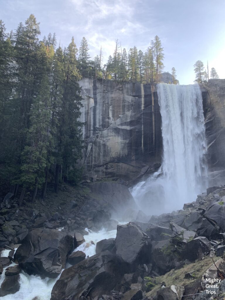
Vernal Falls via the Mist Trail
This is THE Yosemite Hike. Expect to see lots of people on this section no matter what time of the day you decide to go. It is important to note that pets are not allowed on this particular hike. This section consists of a few different parts. The beginning portion is a paved walking path that climbs for a little more than a mile before reaching the Vernal Falls footbridge. At this point, there was a water station and restroom but there were closed at the time.
This is where the real hiking starts as you start to realize why this is called the mist trail. I’ve done this portion a few times and depending on how Vernal Falls is flowing you can expect to get fairly wet (we packed ponchos). There are also a good amount of steep stone steps that can become incredibly slick so be careful with this section.
Once you reach the top, walk over to the falls and snap a picture from the railing before heading off to Vernal Falls!
Vernal Falls to Nevada Falls
Continuing on from Vernal Falls you are treated to more spectacular scenery as you make your way to Nevada Falls. The trail here contains a mix of loose dirt and rock through a covered canopy before climbing up rock steps and switchbacks to the top. We paused every 30 minutes to grab a quick drink and snack along this route which allowed us to enjoy the views and rest our legs. Hikers heading to Half Dome are also taking this route to where it splits near a bathroom. The top of Nevada falls features a footbridge crossing and numerous viewpoints to take in some awesome sights.
JMT / Panorama Trail
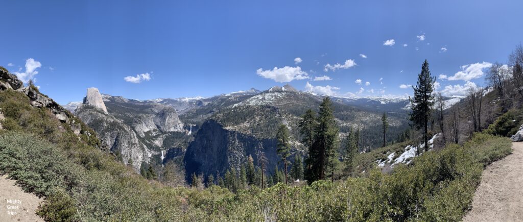
Crossing the Nevada Falls Footbridge will lead you to the start of the next path. To get to the Panorama Trail you will need to connect to it via the famous John Muir trail. This portion of the JMT is mostly uphill switchbacks for about a mile until it connects to the Panorama. One on the Panorama trail the views really open up and you are treated to some different angles of the Valley as well as views of Ansel Adams Wilderness to the East.
This stretch is mainly downhill and does pass Panorama Point, a fairly popular lookout if you want to stop. Once at the bottom, although still high above the valley floor, you will reach Illiloutte creek and falls.
Illilouette Falls
The Panorama trail crosses Illilouette creek via a bridge and Illiloutte Falls (although you won’t actually get to see the falls until later) and this made a perfect spot for us to sit down and have lunch in the shade.
Continuing on from here you will hike uphill to Glacier Point. We started this section in the afternoon and this was the most exposed section of the trail and did get quite warm. Here is your reminder that you’ll want to make sure you pack enough water and snacks for this hike. Also taking a panorama photo on the Panorama Trail only seemed fitting.
Glacier Point
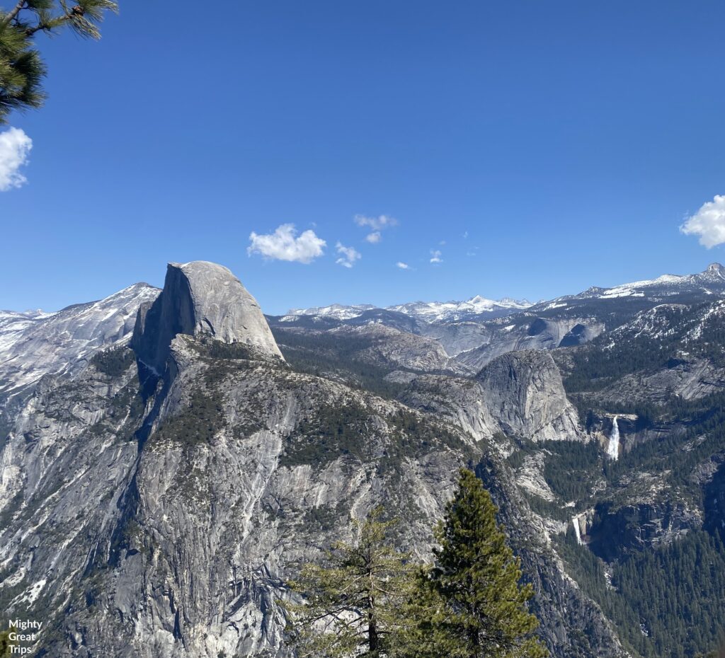
Glacier Point is famous for its outstanding views of many of Yosemite’s breathtaking landmarks, many of which can be seen together. In the image below you can get a nice view of Half Dome, the Liberty Cap, as well as Vernal & Nevada Falls where you started this adventure.
** 2022: Glacier Point is closed to vehicle traffic and is only accessible to Via Four Mile Trail & Panorama Trail
There are no restrooms or water fountains at Glacier Point at the moment but it does boast a fair amount of informational signs and lookout points that I highly suggest checking out while you are there.
You have hiked roughly 10 miles at this point, and the last few have been exposed and uphill. This is the perfect spot to stop and have another snack, rest break and take in the spectacular views before setting off down Four Mile Trail.
Four Mile Trail
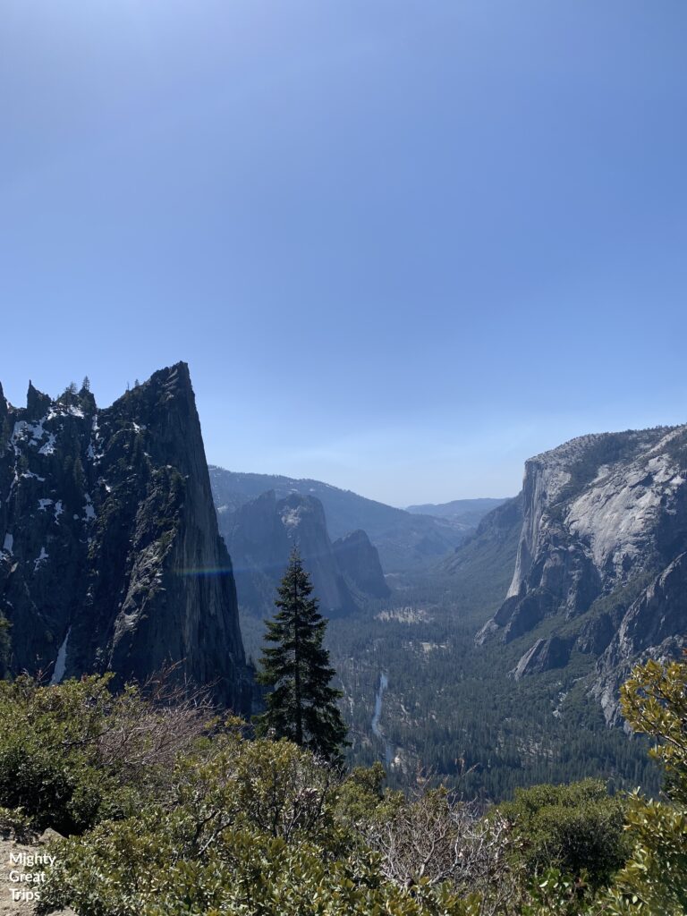
Four Mile Trail is a long descent filled (3,200 feet) with numerous switchbacks and more great views. From this trail you will be able to access Union Point and spot views of Half Dome (if you aren’t tired of looking at it yet), Yosemite Falls, El Capitan as well as the Valley floor, and the Merced River.
The Trail can be dangerous in the winter and is usually closed between December and May with the upper section roughly one mile out of Glacier Point being extremely hazardous.
The trail returns you to the Valley floor just west of the Swinging Bridge recreation area. Depending on where started your hike, you have completed roughly 14-15 miles.
Valley Loop Trail
The valley trail loop is a mostly flat, shaded trail that loops around the Valley floor. You can follow this trail back to your starting point, or there are several shuttle stops along the way if you simply can not bear to walk another mile or two back to camp.
Curry Village
We opted to walk the extra 2 miles to Curry Village on our way back to Upper Pines and reward ourselves with a frosty adult beverage, loosen our hiking boots, and cheers to one epic hike!